Beijing also gives 2 Tibet counties along Indian border city status.
By Sonam Lhamo Singeri and Pasang Tsering for RFA Tibetan

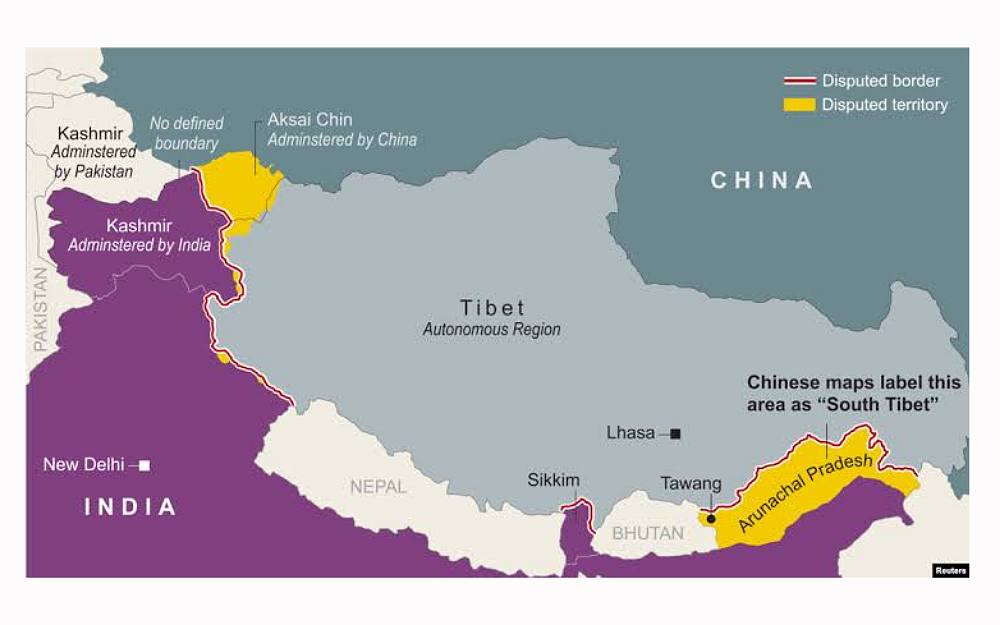
In a bid to deepen claims to territory also claimed by India, China this week announced that it had standardized the names in Chinese and Tibetan of 11 place names in the rugged, disputed area that India calls Arunachal Pradesh and Beijing calls South Tibet.
Beijing issued a map showing the territory clearly belonging to China.
China also upgraded two Tibetan counties bordering India – but outside Arunachal Pradesh – to city status, placing them under the direct administration of the regional government, according to the official Tibet Daily newspaper.
Both moves are apparently attempts by China to consolidate control of the contentious area.
Arunachal Pradesh shares a disputed 1,130-kilometer (700-mile) border with the China-controlled Tibet Autonomous Region in the north at the McMahon Line, a colonial boundary between Tibet and British India dating to 1914. Indian and Chinese troops on the border have clashed several times over the years.
When asked on Tuesday about the reason for the renaming of places, Chinese Foreign Ministry spokesperson Mao Ning told reporters at a regular press conference that Zangnan — China’s name for Arunachal Pradesh — Chinese territory.
“This is within China’s sovereign rights,” Mao said.
Indian officials rejected the name changes.
“We are Indian and [our] nationalistic feelings for Arunachal Pradesh are far more than any other part of India,” said Ninong Ering, a member of the Legislative Assembly of Arunachal Pradesh. “Let sleeping dogs lie. We should not react or pay heed to China. It is nonsense propaganda.”
The name changes are part of China’s geopolitical strategy to challenge and provoke India, said Tsewang Dorjee, a researcher at the Dharamsala, India-based Tibet Policy Institute.
“Strategically, such action from China bothers India as this is the third batch of standardized geographical names for Arunachal Pradesh issued by China,” he said.
“And when we try to analyze all these issues, it comes down to Tibet,” he said. “As long as Tibet’s issue is not resolved, border tension between India and China will remain.”
More local authority
The county-to-city upgrading plan involves Tsona county, also called Cuona or Cona, in the prefecture-level city of Shannan, north of the McMahon Line, the official Tibet Daily newspaper reported Monday. It lies across the border from the Tawang sector in Arunachal Pradesh.
The second county — Mainling, also called Milin — currently falls under the jurisdiction of the prefecture-level city of Nyingchi, or Linzhi, in eastern Tibet and serves as a rail and road transport hub.
Though Chinese officials provided no details about the changes, experts on Tibet said the move has political, if not military, implications given the sensitive location of the places along the contentious India border.
“Changing counties into cities gives more power to the local authorities,” said Kunga Tashi, a Tibet-China expert and a liaison officer in the Office of Tibet in Washington, D.C.
While the immediate intention of the Chinese government remains unknown, its increased attention on Tibet’s border area by advocating border-related infrastructure plans requires a city-level authority to execute the plans, he added.
The change also has military implications because the city units will now come under the direct control and supervision of the China-controlled Tibet Autonomous Region, or TAR, rather than as counties that fall under city supervision, Tashi said.
“The TAR will have full control over military deployments and capability enhancements in the border area,” he said.
Translated by Tenzin Dickyi for RFA Tibetan. Edited by Roseanne Gerin and Malcolm Foster.
Copyright © 1998-2020, RFA. Used with the permission of Radio Free Asia, 2025 M St. NW, Suite 300, Washington DC 20036. https://www.rfa.org.


